


| Where In Algonquin? » WIA 844 » 2/14/2025 12:28 pm |
The answer is March Hare Lake. Someone else can post the next WIA
| Where In Algonquin? » WIA 844 » 2/13/2025 6:42 pm |
Neither of those.
This lake can be accessed a few ways, but on a canoe route wouldn't be one of them. If it was connected to a canoe route, it could be easily reached within a few hours from both Rob and Drew's guesses.
| Catch-all Discussions » GST tax break on freeze dried foods ,, » 2/13/2025 8:39 am |
A heads up about Altitude... I purchased a ton of meals back in December and most of them had incorrect information (eg. calories, protein) on the Altitude website vs. the item received. I did speak to their support to let them know, but I don't know whether or not things got updated. If those numbers matter to you, it could be worth double-checking before purchasing.
I'll also plug Flat Out Feasts, a small company from Edmonton. There was never tax when I purchased last year, I'm guessing because the company is (at least, was) below the $30k/year threshold. The meals are lower in sodium, very high in protein, require very little water and cook time, and have a very simply ingredient list without all of the additives and preservatives.
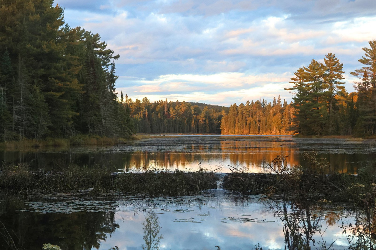
| Where In Algonquin? » WIA 844 » 2/13/2025 8:33 am |
RobW wrote:
Entrance to Tom Thomson from Little Doe
Nope, but it's not too far away
| Where In Algonquin? » WIA 844 » 2/12/2025 4:40 pm |
| Where In Algonquin? » WIA 843 » 2/12/2025 2:55 pm |
Leaving Stutter Creek going back into McCraney
| Trip Planning » PCI Now Has Petawawa River Sections » 1/27/2025 12:22 pm |
If you're referring to the "rapids" campsites, almost all of them will be added in my next batch of campsite reports (within the next couple weeks). If you want to send me an email I'll share the campsite numbers I've already setup on my end.
| Where In Algonquin? » WIA 830 » 1/13/2025 4:47 pm |
Happy Isle at portage to Marchant
That was quick! You're up
| Where In Algonquin? » WIA 830 » 1/13/2025 3:59 pm |
| Where In Algonquin? » WIA 829 » 1/13/2025 1:23 pm |
White Trout island campsite #8
| Catch-all Discussions » Fewer canoe camping videos being released this winter? » 1/13/2025 12:17 pm |
I can't speak on behalf of anyone else, but for me personally it has just been about managing time. My camping season ended early November and I've spent November, December, and now January working on the massive backlog of website content (trip reports, campsite reports, developed campgrounds, and a significant amount of photo processing). I'm hoping to spend a good portion of February and March working on YouTube videos, that will probably get published throughout March - June.
YouTube videos are extremely time consuming to create. Sifting through countless hours of footage, editing it all together, audio level matching, music, transitions, sound effects, exporting and reviewing, thumbnails, etc. Most people don't make money from YouTube (or a very small amount) so it's a lot of work for not much result. I can understand the motivation dropping over time if the channel isn't properly monetized
| Trip Planning » Radiant Lake - 2025 Permits » 1/12/2025 7:30 pm |
This is just my speculation, but I'd guess there are a high number of buffer sites because it's a popular pass-through lake to get in/out of Cedar. Most of the adjacent bodies of water are small lakes and/or river travel with few campsites, so Radiant would be the obvious choice to pull ashore in inclement weather (eg. if you're heading back to the access but don't think it will be safe to cross Cedar, or if you've launched out of Cedar and made it to Radiant and realize you won't be able to make your farther destination). Coupled with the amount of traffic on the lake... cottages, trailers, motorboats... it might also be a popular spot for off-permit camping. Or even if non-campers are just occupying campsites for lunch or a swim at the shoreline, people with a permit could mistake the sites for being occupied. It just seems like a busy 'hub' after long stretches of travel in every direction. Just my guess
Some of the campsites on the north shore have large beachfronts. I don't know about the eastern sites. The west shore are less appealing, based on my own preferences. If you're going during June bug season, the beach campsites might help catch a breeze to help keep the bugs away.
| Trip Planning » Tim River - Shah to Shippagew » 1/06/2025 2:00 pm |
A few points below, but I go into a lot more detail in this trip report:
That was a mid-August trip, so conditions will be different (presumably better) for you in the spring. Most of the beaver dams are west of the Shah portage, but you'll still have a few small ones to cross. The two portages aren't the most enjoyable, but at least they're short. The river begins to get wide after the second portage and is an easy paddle until the end. There are a couple small dams and shallow areas nearby the final 120m portage.
I came from the Little Trout Creek campsite and went to Shippagew. It was a long day but it was doable. Your overall travel time from Shah should be pretty similar to my day.
Feel free to message or email me if you have more questions or need more detail/photos than what I've included in the trip report.
edit: I just noticed you're coming from Timberwolf, not Shah. I still think it's doable especially if you're single-carrying, but it will be a long day for sure. You shouldn't need to worry about any major setbacks because of the Tim though.
| Trip Planning » Shippagew to Longbow via Devine » 12/19/2024 10:32 am |
This might not be too helpful, but I met a group of two men while I was travelling on the Tim River this past August. They had just come from the area you're referencing. It was their first backcountry trip and they were doing a 10-day loop from Canoe Lake, up through that 'unmaintained' area, and back down. It sounded like a crazy itinerary, let alone for a first-time trip. They said it was challenging but they still had smiles on their faces. They did mention the steepness and rough landings, but didn't mention anything else like blowdowns or impassable sections.
| Trip Planning » Preliminary Planning for 2025 » 10/24/2024 8:29 am |
It's a very realistic route, nothing too crazy about it. Your last day could be challenging if there are heavy winds. In late August it took me around 9 hours to get from Little Otterslide down to Canoe Lake because of the wind. My canoe was bouncing up and down during the final paddle on Canoe Lake, the waves were crazy.
If you're camping on Burnt Island though, if the forecast is calling for bad winds you can try to get a campsite on the western side of the lake, to make your final day shorter. Hitting the water early, you would only need to deal with wind on Joe and Canoe, so it wouldn't be too bad.
I've camped on Little Otterslide more times that I have Otterslide, but I do prefer Otterslide as the destination lake. I find the campsites are overall nicer and with prettier views. I always advocate for rest days but if the forecast looks promising before the trip and you want to drop the rest day, you can consider Sunbeam > Big Trout > Otterslide > Burnt Island. Either way I personally wouldn't spend two nights on Burnt Island... even in September it will be very busy and the campsites are not as nice as the other lakes on your route. If you keep the rest day, I'd personally use it on Big Trout instead. Sunbeam > Big Trout x2 > Burnt Island.
| Equipment » New inReach » 9/19/2024 2:18 pm |
Only positive I can think of is if you were in a real emergency situation.
You could send pictures of a bad injury and get back better instructions on what to do until help arrives. That’s about it.
It can also be nice to have someone send an image of a detailed weather forecast from your preferred website instead of using the forecast from Garmin
And the voice messaging you can say a lot more in 30 seconds than you can type in the 160 character SMS limit (even though it seems like voice + pictures have an extra fee)
What's funny is they announced this new product hoping it will get all of the attention, while they're also changing their plans... raising prices and removing free monthly suspension. I'm having serious thoughts about getting rid of my InReach Mini after the plan changes.
| Trip Reports » Dodging the Elements - A Weekend out of Shall Lake (Shirley, Booth) » 8/27/2024 4:26 pm |
Sounds like a great trip! Was there any logging going on while you were there? When I was at that campsite on Shirley I saw people going for a swim down the shoreline (from the logging camp) but the noise wasn't too bad thankfully.

 1
1