


![]() Offline
Offline
I am planning a trip for the end of August and am considering doing a significant bushwack portage as part of the trip. My goal is to start the day in the Opeongo North arm, paddle hailstorm creek and then bushwack into Hailstorm L, CrossBill L and finish the day in Burnt Island L. Based on google maps it looks to me like most of Hailstorm L and Crossbill L will be paddalable. I anticipate the hardest parts will be the several hundred meters of marshy zone between the lakes and dry land. Beyond that it looks like there will be around 3km of total portaging over dry land, which will be very time consuming but looks straightforward.
I have done bushwhack portage routes like this a handful of times in the past and am familiar with the general unpredictability and challenges that I may encounter. I am mostly curious if anyone has any information specific to this route / area that they would be able to provide. Has anyone done a trip through here? Are there any old logging roads I can use to portage? Are my intuitions about water levels accurate?
Any help would be greatly appreciated.
Last edited by AaronBanks (7/22/2021 3:14 pm)
![]() Offline
Offline
I don't envy that last stretch. Be sure to come back with a report 🙂
![]() Offline
Offline
Jeff's Maps has "traditional" portages drawn but they're drawn ruler straight so they might just be rumors of old portages.
![]() Offline
Offline

I think Crossbill lake may be an intereting place to try to get to but I haven't yet attempted it. When looking on Ontario's topo map site you can see a dark straight edge arount the marshy evergreen forest in the middle of the map, between Crossbill and Burnt Island, that suggests there may be a cleared road there. Or, maybe it is just an optical illusion. I don't see any logging roads on the map so unless new ones were built recently (I doubt it) then it may be worthwhile to try to follow that dark edge around the marsh as it also follows an elevation contour line. Good luck and please report back on your trip.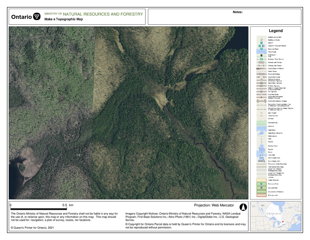
![]() Offline
Offline
I have no idea but will second solos recommendation to use the Ontario imagery software instead of Google Maps. Way higher resolution:
![]() Offline
Offline
keg wrote:
Jeff's Maps has "traditional" portages drawn but they're drawn ruler straight so they might just be rumors of old portages.
Exactly. The information of where these portages were could be 100 years old. That being said, there are/were logging camp remnants on Cross Bill from the 40's so people were accessing it at one point in time. I think the worst part of this will be going from the creek to Hailstorm L. Moose muck up to your waist and I doubt the narrow end is passable. A GPS would be useful so you don't end up way off track.
![]() Offline
Offline
Jeff's Maps has "traditional" portages drawn but they're drawn ruler straight so they might just be rumors of old portages.
Exactly. The information of where these portages were could be 100 years old. That being said, there are/were logging camp remnants on Cross Bill from the 40's so people were accessing it at one point in time. I think the worst part of this will be going from the creek to Hailstorm L. Moose muck up to your waist and I doubt the narrow end is passable. A GPS would be useful so you don't end up way off track.
I would expect that Jeff got the historic portage information from either the 1925 or 1941 Arthur Brown maps of Algonquin Park.
![]() Offline
Offline
I appreciate the recommendation about the MTO maps website, I'd totally forgotten it existed. Much better information on here than google maps. I've spent the last two hours making and printing off maps!
I'll be sure to come back here and post an update if I am successful in navigating this stretch.
![]() Offline
Offline

Portage Store employees have done that a couple of times. I think that's actually where Jeff got his info.
I've done a few long bushwhack portages in my time. My advice is to look for hardwood forests, high ground and do it in the early spring. Trying to push through creeks and black spruce swamps in summer can be impossible.
I have been told the hardest part of that route is getting out of Hailstorm Creek. Dense, wetland bushwhacking. The area is riddled with somewhat maintained trails which follow the Madawaska. There is also the remains of an old logging road which accessed the lumber camp. But, they go North/South down to the Wildlife Research Station and not East West.

 1 of 1