


![]() Offline
Offline
Looking for a bit more route planning advice.
I have a second route to plan and was thinking about entering in Craig Lake and doing two nights on Craig, and one night on either Pishnecka or Charr Lake. Not sure on the route yet. It looks like there are some very nice spots on Craig Lake from other reports. Any thoughts on if Charr or Pisknecka are worthwhile to camp on?
The road in looks decent to enter at Nahma (lb on Jeff’s map), but any thoughts on the drive is welcome. As well, I read one report that someone staying on Craig Lake noticed lots of logging vehicles. Does anyone know if this is still an issue?
![]() Offline
Offline
1. You can park just south of the 2nd bridge over the South River (space for one or two vehicles) then follow an obvious forest trail for about 150m to the first un-named pond. This is easier than launching directly on the South River, paddling 30m then hitting a portage to the same pond.
2. Craig is nice, but doesn't feel remote. You might hear logging trucks ripping it up and down the road, you might not - depends on the time of year and where the logging operations are for the given time. The issue I have with Craig is the giant concrete dam on the north shore - it's visible from all but one campsite on the lake and I feel it takes away from the scenery - esp. the giant orange booms.
3. Pishnecka is a beautiful Lake. The west site is a big rock, the east site is a giant beach - both decent and both better than Charr Lake.
here is the alternate entrance and parking I speak of: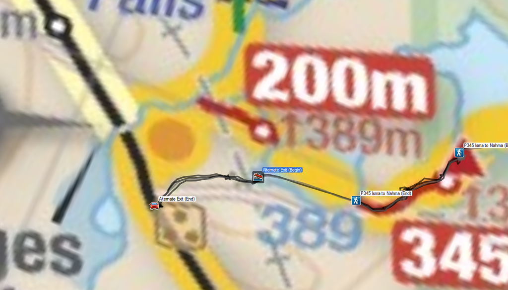
Edit: Corrected a double-negative.
Last edited by Peek (5/03/2017 9:52 am)
![]() Offline
Offline
This was VERY helpful Peek, thank you!
I think if we do this trip, we will instead travel through to Pishnecka and do 2 nights there (maybe explore the surrounding lakes), then back out to Craig for one night. Sounds like Pishnecka would be worth the visit and would have the more remote feel.
I'll keep looking around for some other routes in that area that we have not yet done too.
![]() Offline
Offline
Thanks Peek! I'll actually be on Pishnecka this summer, so good to know :-):-)
![]() Offline
Offline
Peek wrote:
1. You can park just south of the 2nd bridge over the South River (space for one or two vehicles) then follow an obvious forest trail for about 150m to the first un-named pond. This is easier than launching directly on the South River, paddling 30m then hitting a portage to the same pond.
2. Craig is nice, but doesn't feel remote. You might hear logging trucks ripping it up and down the road, you might not - depends on the time of year and where the logging operations are for the given time. The issue I have with Craig is the giant concrete dam on the north shore - it's visible from all but one campsite on the lake and I feel it takes away from the scenery - esp. the giant orange booms.
3. Pishnecka is a beautiful Lake. The west site is a big rock, the east site is a giant beach - both decent and both better than Charr Lake.
Is this information still accurate?
here is the alternate entrance and parking I speak of:
Edit: Corrected a double-negative.
Is this information still accurate?
![]() Offline
Offline
Pishnecka is totally worth it. Cant go wrong with either site. I think Craig may get busy with partying local weekend warriors. The beach site is super shallow. Gotta go out far to swim. Bottom covered with mussels. Bring water shoes. Id say there was room for 4 to 5 cars at the parking spot. South of South River.we were there 3 years ago. Enjoy. Cool part of park that doesnt seem to get much use.
Last edited by Shayne74 (6/05/2025 8:14 am)
![]() Offline
Offline
Sorry I wasn’t clear. I was asking about if it was still ok to park south of the second bridge.
![]() Offline
Offline

Unless something has changed very recently then it's ok to park there. If you look at the aerial view you can see what appears to be two small clearings on the north side of the road, one 200 m past the bridge and the other 400 m. I can't remember which is the actual parking spot but it should be obvious as there will likely be a car there and there is a portage leading towards the unnamed pond.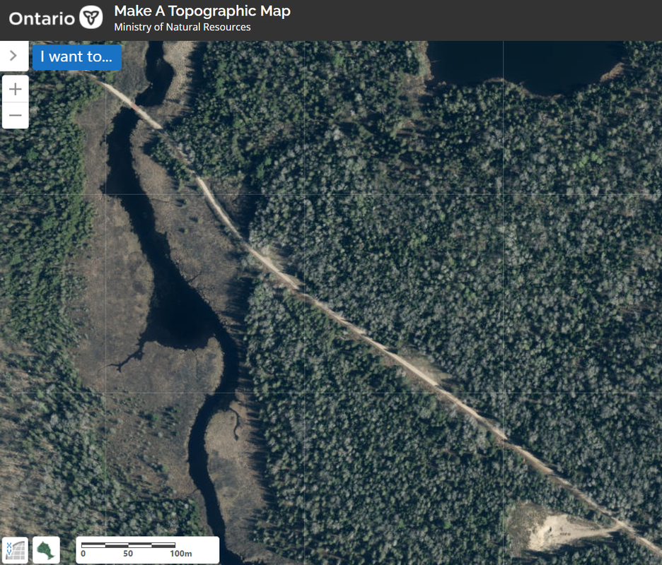
![]() Offline
Offline
Thanks, to both of you.

 1 of 1