


| Trip Planning » North River Lake or North Depot/Allan Lake » 3/27/2023 10:59 am |
Lenny wrote:
Worst part about going there is the Wendigo Lake parking lot is often packed and the road going in can be very rough.
I know a few years ago the road got washed out. Not sure if it's been repaired.
But the road was rough when I went in 2018 - I think the road got washed out in 2019.
We stayed on North Depot on south most island, It was a great little site!
| Trip Planning » Lockdown extension? » 5/19/2021 11:19 am |
@Mulder, I think the lockdown is until June 2nd inclusive. Might want to check on that.
Yes, I just got the partial cancellation email. Says I can change to Thursday the 3rd if I want.
| Trip Planning » Lockdown extension? » 5/19/2021 6:13 am |
Well, 2 weeks until my trip and it hasn't been cancelled (scheduled to arrive June 2nd).
Here's hoping!
| Trip Planning » Questions from a first timer, reservations, safety, » 7/07/2020 7:45 am |
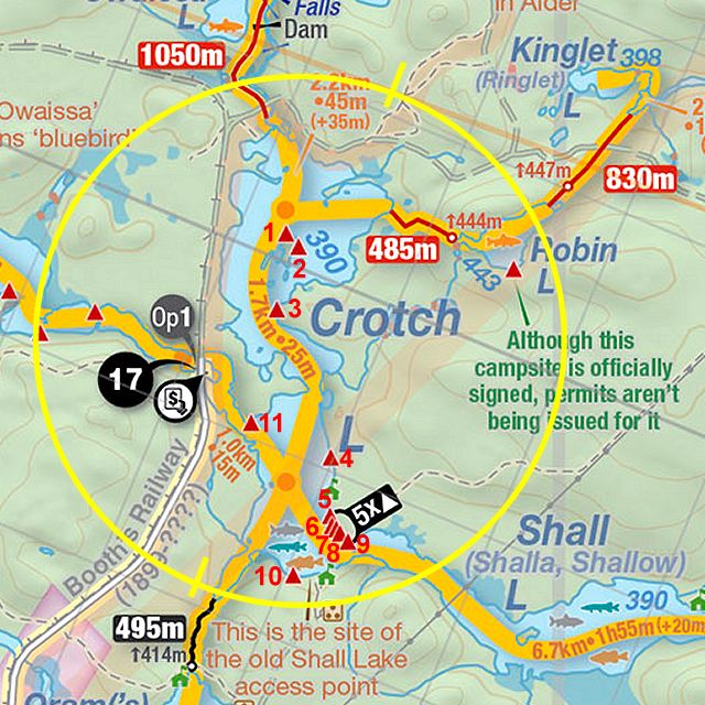
2) I've seen people bring in coolers before. Even on Crotch Lake (as Park staff watched). I don't think they are a big issue on these lakes as they are popular, and you canoe right to the site.
I bought this prior to my trip 3 weeks ago and it worked great.
We put Meats/Cheese/Eggs/Veggies etc.
3) I've camped on Site #1. It was very nice but you might share the island.
I'd avoid site #3 (on hill) and site #11 looked small.
Sites #4 to #9 are big but very close to eachother. (It's like you are car camping close) low lying and good beach.
#10
| Trip Planning » Fees » 7/02/2020 7:18 am |
Has anyone done this yet? I'm seriously considering it for my group, but I'm pondering the ethics. There's three sites on the lake I've booked. So far I've only booked for myself with the plan to add others the day before we leave...
The ethics are very black and white, very little grey area to work with. I’m not saying that I‘m all high and mighty but in this situation I would probably do something different. That being said, there doesn’t seem to be a rule against it and there is an economic advantage to you as well.
My group has done this once. (There is usually 4 people in our group).
I'll take flack for this, but only because we wanted to limit the number of available sites on Opalescent. (We really wanted the Stone couch site) There are 6 sites on the lake 5 available for booking and we booked 2. We only ended up seeing 1 other person (didn't stay on the lake) and 2 park staff (first and only time for park staff)
| Trip Planning » Reservations starting from unofficial access points? » 5/31/2020 7:42 am |
Plenty of parking off to the side of the Sunday Lake Access point at the head of the portage.
But could always park at Big Pines Trailhead and make that 1.5km walk back to gear?
| Trip Planning » June 1 opening » 5/30/2020 8:19 am |
| Trip Planning » June 1 opening » 5/29/2020 6:10 am |
Yeah, why would they suspend one service and not the other if the plan is to keep the Park closed? No logic in that. Looking positive.
Perhaps a phased in opening for camping, Backcountry, low risk, if it's OK, partly open front country.
I suspect we will get an announcement on when camping is going to happen today anyways.
It's frustrating for me, I leave the 18th for my 5 day trip.
My company put all vacations on hold, I can likely still get approval on short notice. (After working from home for almost 3 months, I could use a break from home)
| Trip Planning » June 1 opening » 5/28/2020 2:58 pm |
For what it's worth, I contacted the place we were renting canoes from for our trip Mid-June and they said no word yet, but Parks staff is in the park and getting ready.
| Trip Planning » Ontario to reopen provincial parks for day use starting Monday » 5/11/2020 4:59 pm |
@Mulder
The fact is they never had enough test kits to test for the corona virus. Especially during the beginning of the outbreak. This was a worldwide problem. In March, people without a suspect travel history in Canada, who were sick, had the symptoms and were expecting they were infected they were send home, told to isolate but were never tested. As a result they are not included in the confirmed numbers. They still only perform a limited amount of tests.
Governments in other countries wanting to know the real scope of the infections and death rates performed random street tests. These tests on the low end indicated ( This one was done weeks ago in the Netherlands so by now the numbers are higher. ) a 4% infection rate. BTW as far as I know Canada still has not approved this (blood) test they use for this.
I can also come up with a higher death rate for the flu. If you like to go with the confirmed deaths that start out as flu, turn into pneumonia and then result in death is 8000 per year in Canada. This would give a death rate of at least 14.5%.
Anyway all beside the point I was trying to make. At the moment people are presented with these high death rates while in reality they are no were near the +/-7% the official numbers suggest. Most likely they are around 0.175%.
Another interesting bit of information about new York. New York Gov. Cuomo actually mandated early on during the outbreak that nursing homes take on Covid 19 patients….That’s why they have sky high number of deaths in their Nursing homes.
There is no point to this, you are ignoring what MANY health agencies, epidemiologists and studies are saying. You are choosing to take the numbers and manipulate them to get your desired results. Can't reason with that, sorry.
| Trip Planning » Ontario to reopen provincial parks for day use starting Monday » 5/11/2020 1:26 pm |
@ Mulder:
For the official Canadian Influenza numbers:
So if you would go with the absolute lowest number of annual deaths (500) and take the year with the highest number of cases (55059) you would get a death rate of over 0.9%. Now if you would use the number of annual deaths (8000) due to the combined, influenza and pneumonia deaths, which is a common complication of influenza, the death rate would be much higher.
Now I would not look at the New York numbers as they initially didn’t impose any restrictions and then after they realized things were already totally out of control did…..
If you want to compare apples to apples, Canada's current confirmed Cases of COVID-19 is 66,996, with 4,728 deaths. Indicating a death rate of 7.06%.
You can't decide to throw in a bunch asymptotic/carriers in your calculation for COVID deaths and then totally ignore it for the Flu.
| Trip Planning » Ontario to reopen provincial parks for day use starting Monday » 5/11/2020 7:00 am |
. The result is that the actual cases are many multiples of the official confirmed cases. If you would go with the 4% and apply it to Ontario than that would mean there most likely are actually already about 600000 cases in Ontario resulting in a death rate of 0.175%. This is a lower death rate than the yearly flu.
"The Flu" is a broad term that covers a range of viruses.
Your assertions/assumption is also far correct.
From New York City, they already have deaths AND Antibody testing, And they have already lost around 0.3% of their population from COVID, and counting.
To contrast, the last major Flu Pandemic H1N1 of 2009, estimated to have killed between .01% - .03%. of those infected, and THAT was considered a bad flu year.
| Trip Planning » scorch lake water level and campsite » 7/15/2019 12:13 pm |
I wish I saw this thread earlier, I have a recent trip report from fall 2017 with lots of details and pictures for most campsites in the area (see my site in my signature). Probably could have helped with your planning but it’s a little after the fact now lol
We found your trip report and campsite pictures a few months ago, that helped with us picking the campsite, etc.
Judging by your pictures that you have, the water level is at least 1-2 feet lower today, that beach firepit on campsite #4 while still there, the beach surrounding it is completely covered in shrubs and other vegetation.
We were able to find Campsite #1. Didn't have a camera with us, but it was in really really bad condition.
| Trip Planning » scorch lake water level and campsite » 7/15/2019 7:31 am |
You could get there by either route, the best might be to go there from Kingscote and out by the river, I think you can arrange a shuttle back to your car from Pine Grove Point fairly affordably.
I'd agree with taking the easternmost campsite on Scorch if you can.
Getting onto the main part of the lake from the portage might be challenging. It was a bit of a rock garden when I was there a few years ago and I've also heard the dam broke, that would mean the beaver dam at the outlet of Scorch Lake (near the portage where a creek drains it into Branch Lake) so that might lower the water levels a bit. I'm sure it's still doable but it might take some extra portaging or wading.
Don't miss the short hike to the lookout.
Lots of wading and extra portage probably 200m+ we were able to put in and paddle for about 50m before we just had to pull the canoe. Sometimes ending up waist deep in muck There was a small beaver dam at the end and we were able to paddle from there.
Looking at previous pictures it's crazy to see how much this lake level has dropped even from 2014. (Sometime between 2009 and 2012 is appears the first major dam broke - and an additional one broke sometime after 2014). Does make it difficult if you planned to get there on day 1. We left Kingscote about 10:00 (due to storm) and got at the site at 6:30pm.
Heading home along the river route to do that loop there was at least 3 beaver dams we had to pull over, some very impressive, at least 2 over a meter tall, and one that basically surrounded us as we pulled into it. Very cool.
Alot of the Portage signs are missing. We needed up missing the one near the Gut Rapids Trail, pulled over a beaver dam, found the trail then had to double back. and pull back over the beaver dam. Probably lost an hour of time there cause we got lost.
We ended up leaving our site on Scorch Lake at 8:10 and in Pine Grove Point just before 6.
| Trip Planning » Wendigo Road » 7/15/2019 6:50 am |
I was able to get an SUV and a toyota camry down that road last year. It was a little tricky for the camry coming across the beaver dam area then up a sandy hill.
We were told by Park staff that there is disagreement between the Park and Logging companies on who maintains the road. It has ended in a stalemate I guess until the logging company gets to log in that area again.
| Trip Planning » scorch lake water level and campsite » 3/12/2019 8:26 am |
Heading to scorch lake in July for my annual camping trip with high school buds.
I've seen recent posts and pictures about water level being down alot, is this a concern? I think I read that a dam broke, can't remember where.
This will likely be the furthest we've gone interior too, or very close to North Depot last year. I'll have to check.
Is there any suggestion on route ? Do we take the river up (from where we get out permits and canoes, Pine Grove point) or go though Kingscote?
Also, any suggestions on a campsite once we get there? The only thing I've been able to find is not to pick the first one we come across.
I'm hoping (I say this every year tho) to get a bunch of pictures of all the campsites and contribute to the PCI project. I just need to do the write up for Sunday, Crotch, Basin and North Depot from our last 5 years. ![]()
Thanks in advance!
| Trip Planning » Crossing algonquin park » 7/19/2018 6:57 am |
I would start with the choke points that you have to hit and work your way back.
For Example - the only way to get to squirrel rapids from the west is thought one area. that have two different routes.
One is 3 separate cart trails and a road that is probably going to equal a 22km portage. (McKaskills Lake to the the River above Carcajou Lake)
The second is the low maintenance route from White Partridge Lake to the same area. ~ 10 km of portaging.
Consider that if you can't single carry. That's alot of walking.

 1
1