


![]() Offline
Offline
Hello AA Community - I need your help!
Has anyone on here ever used P3565 along the Little Madawaska River, just upstream of Radiant Lake?
I ask because I went UP this river to Philip Lake back in 2013 and my buddy & I could not find the portage landing - period! (The river splits up into many channels here) We ended up river walking to the bridge, then portaging the logging road west of the river and bushwhacking back to the river at the dam - it worked but it was a lot of effort and energy that could have been saved by knowing where and using the actual portage.
Well, I'll likely be going that way again this June and our travel day will be Radiant to Hogan, so I really don't want to mess around and waste time looking for a landing.
So I ask if anyone has used it, recently or not, and if they can provide any insight to locating the landing, or the trail. I'm using the MNR 'Make a Topo' high-res Satellite images and usually you can see a landing and follow the trail through the forest, but not here. I can see what appears to be an ATV trail off to the east of the river, and it follows the 'same path' the portage would likely supposed follow - but its 400 to 500 m east of the river - which seems very far away and I can't imagine why the portage would be cut so far away from the river - unless there was already an ATV trail or tertiary road in the area and they decided to take advantage of it for the portage.
Anyway, enough speculation on my part - if anyone has info on this I'd greatly appreciate it.
Thanks everyone!
![]() Offline
Offline

Yes, I have done this. The start of the trail is on your LH side going up the Little Mad. It follows the river for some time and crosses the road that you took before. However, it is easier to take the road up to the dam. From the road you were on, you don't have to bushwack to get to the dam. There is an old road that connects to the road you were on that takes you to the dam. You need a topographical map!
Last edited by boknows (4/26/2017 3:22 pm)
![]() Offline
Offline

Well you just worried the crap outta me.
I haven't been, no - but that's going to change in about two weeks when my trip has me heading from Radiant to Philip. My research didn't turn up much about that portage. I found a Larry Hyett video covering that stretch (and I exchanged some messages on Facebook with him asking for more information), but they hopped on the logging road where it intersects the river (or possibly even from Radiant itself - didn't clarify that), so we didn't discuss the start of that 3565m portage since he was never on it.
My own plan was to take the 3565 as far as the bridge then take the logging road the rest of the way and then bushwhacking as you did around the dam area (as Larry did as well). Now you've got me wondering if I should just say to hell with it and take the road from the get go. I really won't want to be wading the Madawaska in early May... my legs are going numb just thinking about it.
Boknows might know something. He chimed in on that stretch in my own trip planning thread. I'm going to double-check what I can find online because you've got me worried.
Edit: and Bo posted while I was still typing away. Did you find tthe portage start difficult to find? How long has it been since you've been that way?
Last edited by Uppa (4/26/2017 3:22 pm)
![]() Offline
Offline
I never had trouble finding the start of the long portage. Last I was there was 7 years ago. Do not take the road from Ogdenback(sp) station. Too far to carry your gear. Best way is take the portage to the bridge on the road, turn right and follow road to this other road that will take you to the dam. It is best you get a topographical map so where where this road is that takes you to the dam.
Last edited by boknows (4/26/2017 3:25 pm)
![]() Offline
Offline
I've got Jeff's map loaded on my phone, which, aside from listening to music, will be the one other purpose it serves on this trip - to figure out where to bushwhack back to the dam. It seems quite a few people have done this, sort of surprised nobody's marked a route with flagging tape by now.
![]() Offline
Offline
Uppa - Don't worry, it'll just be more of an adventure! I'll be looking to you for better information after your trip ![]()
BO - yeah it was weird, this was the only portage in 80 canoe trips that I could not find. I think we went up the wrong channel, then decided to say screw it at the bridge and walk the road - its entirely possible that had we walked east instead of west (to the road) we would have found where the trail crosses the road.
When we were walking the road, I remembered that Jake from Brent told me there is a road leading right to the dam - just as you mentioned - thing is - we couldn't find that either!!! I mean, cmon, how hard can it be to find an old road? We scanned and scanned but found nothing. It was hot and sunny, maybe we just plain old missed it - but thats why we ended up bushwhacking to the river.
Bo I know it's been 7 years, BUT, do you happen to remember how close to the bridge the trail crossed the road? 50m? 500m? I see a bunch of trails in the area but none seem to match up to Jeff's Map (though I know this portage hasn't been GPSed).
I'll definitely check some topo maps.. but even online using the high res imagery I can't see the road leading to the dam - or even a tree outline that could have been a road. weird eh?
![]() Offline
Offline
I would say less than 50m....I had a topo map 7 years ago that showed be this road to the dam. It was a good road back then but now could be somewhat overgrown with weeds, grass, etc.
Last edited by boknows (4/26/2017 3:44 pm)
![]() Offline
Offline
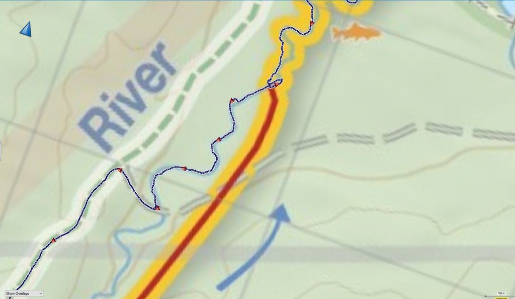
Here are my GPS tracks from that trip. As you can see we scanned the riverbank where the portage is supposed to begin, but found nothing. However, you can also see that we took a different 'channel' not marked on the map (See the satellite image below to see what I mean) which means we could have missed it if it was in a different channel. hmmmmm...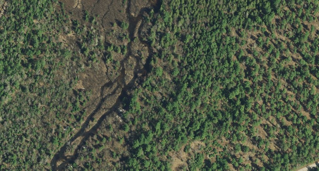
Last edited by Peek (4/26/2017 3:46 pm)
![]() Offline
Offline

The start of the portage from the radiant end is a little weird. In 2013 the river had undercut the bank at the portage. So the end of the portage trail was actually a couple of feet above water level. Then a vertical drop to the river. It was a grassy spot. I suppose you could miss it if you were sitting in your canoe.
I don't think the trail is 50m from the bridge. I didn't bother to stop at the road because I was single carrying. But I did look left/west. I remember hearing the river but not seeing the bridge. But I didn't stop for a good look.
I wouldn't bother with the road at all. Just stick to the trail. It's not difficult, just slightly uphill the whole way. I really liked going down that portage.


 1 of 1